| | Welcome to the OSGeo:UK Newsletter |
|
Hello, and welcome to another OSGeo:UK newsletter. Every couple of months, this is where we share updates and information about the OSGeo:UK local chapter, along with other FOSS for geospatial goodness. Please share the newsletter widely so that interested friends and colleagues can sign up too. For now, enjoy this edition. |
|
Find out more about OSGeo:UK and how you can be part of our community on our website. |
|
FOSS4G:UK 2026 is Coming to Leeds!
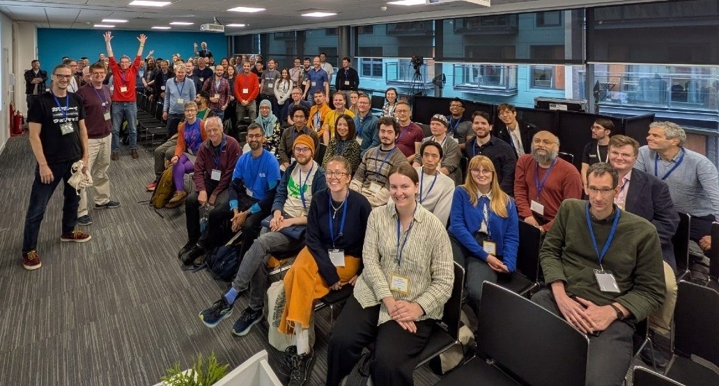
We are delighted to announce that FOSS4G:UK 2026 will be returning to Leeds this autumn. The event will be taking place on Monday 12th and Tuesday 13th October at the wonderful Horizon Leeds venue. Building on the success of last year's event, the conference will once again offer two full days of talks and workshops spread across multiple rooms, packed with open source geospatial content, lively discussion, and plenty of opportunity to catch up with colleagues old and new. Whether you are a developer, researcher, consultant, practitioner, or part of a public sector or community group, this is the premier national gathering for the open source geospatial community in the UK.
Further details on registration (including special tickets for students and additional low cost tickets ) and the programme will be announced in due course, so keep an eye on the official website at uk.osgeo.org/foss4guk2026 for updates. As always, the event is guided by an inclusive Code of Conduct, ensuring a welcoming environment for all attendees. Mark the dates in your diary now as you won't want to miss it!
FOSS4G:UK 2026 SPONSORSHIP!
If your organisation is keen to support the event, sponsorship packages are available. This is a fantastic way to raise your profile within this vibrant and growing community and to support the OSGeo:UK volunteers in continuing to put on events like these. We have additional sponsorship opportunities this year: the social event and the OSGeo:UK AGM can be directly sponsored! All of the details are listed here: https://uk.osgeo.org/foss4guk2026/sponsor/ |
|
FOSS4G 2027
Plans continue to progress towards the UK hosting the international FOSS4G in 2027 in Bristol. The bid team are currently responding to questions posed by the core OSGeo Global committee so it won't be long now before we'll be able to share more information about the bid status. As ever, if you want to help with the bid, please get in touch using osgeouk@gmail.com. Additionally, there will be plenty of opportunities to get involved when the bid is a success. |
|
Do You Know About OSGeoLive?
Have you ever wanted to explore the vast world of open source geospatial software but felt put off by the prospect of installing and configuring a whole suite of unfamiliar applications? Well, here's something you may not have come across before: OSGeoLive is a self-contained bootable USB thumb drive (or Virtual Machine) that allows you to try a wide variety of open source geospatial software without installing anything. That's right — you can simply boot it up and start exploring, with no impact whatsoever on your existing computer setup. It's a brilliant resource, and is completely free (although if you find it useful you should make a donation).
The current version has been around a while (released in 2023) but if it works, it works! OSGeoLive comes pre-installed with close to 50 quality geospatial open source applications, ready to use straight away, along with free world maps and sample datasets, project overviews and step-by-step quick-start guides for each application. Whether you fancy taking PostGIS for a spin, having a look at GeoServer, or experimenting with any number of other tools you've heard mentioned at conferences but never quite got around to trying, OSGeoLive hands you a fully configured sandbox to do exactly that. It has long been a popular fixture at workshops and conferences, where it enables participants to hit the ground running without any of the usual setup headaches. It's also an excellent teaching tool - if you're introducing colleagues or students to open source GIS, there really is no easier starting point. Head over to live.osgeo.org to find out more and download the latest version. You might just discover your new favourite tool. |
|
QGIS 4.0 Is Here!
The open source geospatial world has reached a landmark moment: QGIS 4.0 has officially been released. For the millions of users and developers who rely on QGIS as their go-to desktop GIS platform, this is more than just another version bump: it represents the culmination of years of careful, community-driven work. At its heart, this release marks the completion of the long-anticipated migration from Qt5 to Qt6, a foundational shift that sets QGIS up for a new era of performance, security and compatibility with modern software libraries. If you haven't already downloaded it, now is very much the time. However, for those of you who are a little more cautious about shifting to new versions of software, you might want to check out the following blog post by OSGeo:UK's very own Nick Bearman, who provides some handy info for Windows users: https://nickbearman.com/blog/2026-03-qgis-4-is-out/index.html
For many users, the good news is that QGIS 4.0 will feel reassuringly familiar. The interface and workflows you know and use should remain very much intact - but don't let that familiarity fool you into thinking nothing has changed. Under the bonnet, this release is transformative. The Qt6 migration brings meaningful performance improvements and vital security enhancements, whilst unlocking access to a host of modern libraries that will benefit the project for years to come. On top of all that, the developer community has managed to pack in over 100 new features alongside the migration work, making QGIS more powerful and flexible than ever. The QGIS Hub has also seen exciting growth, with users sharing an ever-expanding collection of projects, styles, scripts, and resources. For plugin developers, the transition has been made as painless as possible, with a dedicated Qt6 compatibility guide to help ensure existing tools work smoothly with the new release. To explore everything that's new, check out the highlight reel on YouTube or dive into the full visual changelog. Happy mapping! |
|
Have Your Say: QGIS Survey on Open Source GIS in the Public Sector
The QGIS Trainer Network established at last year's FOSS4GE conference in Mostar, Bosnia-Herzegovina, is calling on public sector professionals and university representatives across the UK to take part in an international survey on open source GIS. Coordinated by Kurt Menke on behalf of the network, and approved by the QGIS Project Steering Committee, the survey is particularly keen to hear from those working in or for the public sector, including contractors, local authorities, central government bodies and higher education institutions. Whether you are a seasoned QGIS user or rely on other open source GIS tools in your work, your experiences are valuable and your input is actively sought.
The survey explores the opportunities and challenges of using open source GIS in professional and academic settings, with the aim of developing teaching standards, best practices and educational materials that reflect real-world needs. This is a genuine opportunity to help shape the future of open source GIS education, not just in the UK, but internationally. Responses are needed by the end of April 2026, and the findings will be presented at the QGIS User Conference 2026 in Laax, Switzerland (5–6 October 2026). The survey takes just a few minutes to complete and can be found at: https://docs.google.com/forms/d/1RgEfNxXi2jmVBctcbvnpR2IGNYW6QIas4KqdeH4aP4I/viewform. Please do share it widely with colleagues: the more voices heard, the better the outcome for the whole community. |
|
Tell us about your work!
You can submit news stories to be highlighted in this newsletter by supplying suitable details for us to add to a future newsletter issue. We are always looking for individuals willing to write a short thought piece, no more than a few hundred words, for inclusion in future newsletters. Use the same link to submit an idea, which can be about anything to do with the concept of 'open' in geospatial, and we'll get back to you if we'd like you to write that up. |
|
We hope that you found this edition of the newsletter interesting and informative. If you have any feedback or comments then let us know! You can check out the Dec 2025 and Feb 2026 newsletters and feel free to share this and previous newsletters with your colleagues and friends. |
|
|
| |
| |
|